


Image Credit : All images are the property of NFP Tech
Project Overview
For too long, charities and not-for-profits have been held back by limited knowledge of technology; how it can assist them in measuring their impact, how it can empower their dedicated staff and volunteers to perform their work more efficiently, and the many other ways it can positively contribute to their purpose. Furthermore, private technology companies have taken advantage of this lack of knowledge, by charging exorbitant fees for unnecessary costs, inflated overheads, and intentionally creating reliance on their private services rather than designing products that will enable organisations to use technology on their own.
As a not-for-profit serving other not-for-profits, NFP Tech seeks to disrupt an industry rife with exploitation. We operate a funding model aiming to keep costs as low as possible for the charities we serve, and whenever possible, we allow tech products to be provided without charge to organisations with low surplus funds. When financial targets are reached, supplementary funding will not be delivered to profit participants, but re-invested back into our mission through enhancements to existing products, or the creation of new products as requested by stakeholders from the community services sector.
“Mapping App” is the first product created by NFP Tech, in collaboration with the talented team at Doculocker. The product has been mostly self-funded by the director ($80,000) alongside a generous grant from Yarra Ranges Council to cover Google API costs for small organisations in the region that could not afford to participate in the trial, ensuring equity and inclusion for all services regardless of their size or funding surplus.
Project Commissioner
Project Creator
Doculocker in collaboration with NFP Tech
Team
Ciara Placentino (Director of NFP Tech) - UI/UX Designer
Hendrik Gani (Director of Doculocker) - Project Manager and Lead Software Developer, Backend
Reece Armes - Software Developer, Frontend and UI/UX Designer
Keiichi Katsuno - Volunteer Software Developer
Project Brief
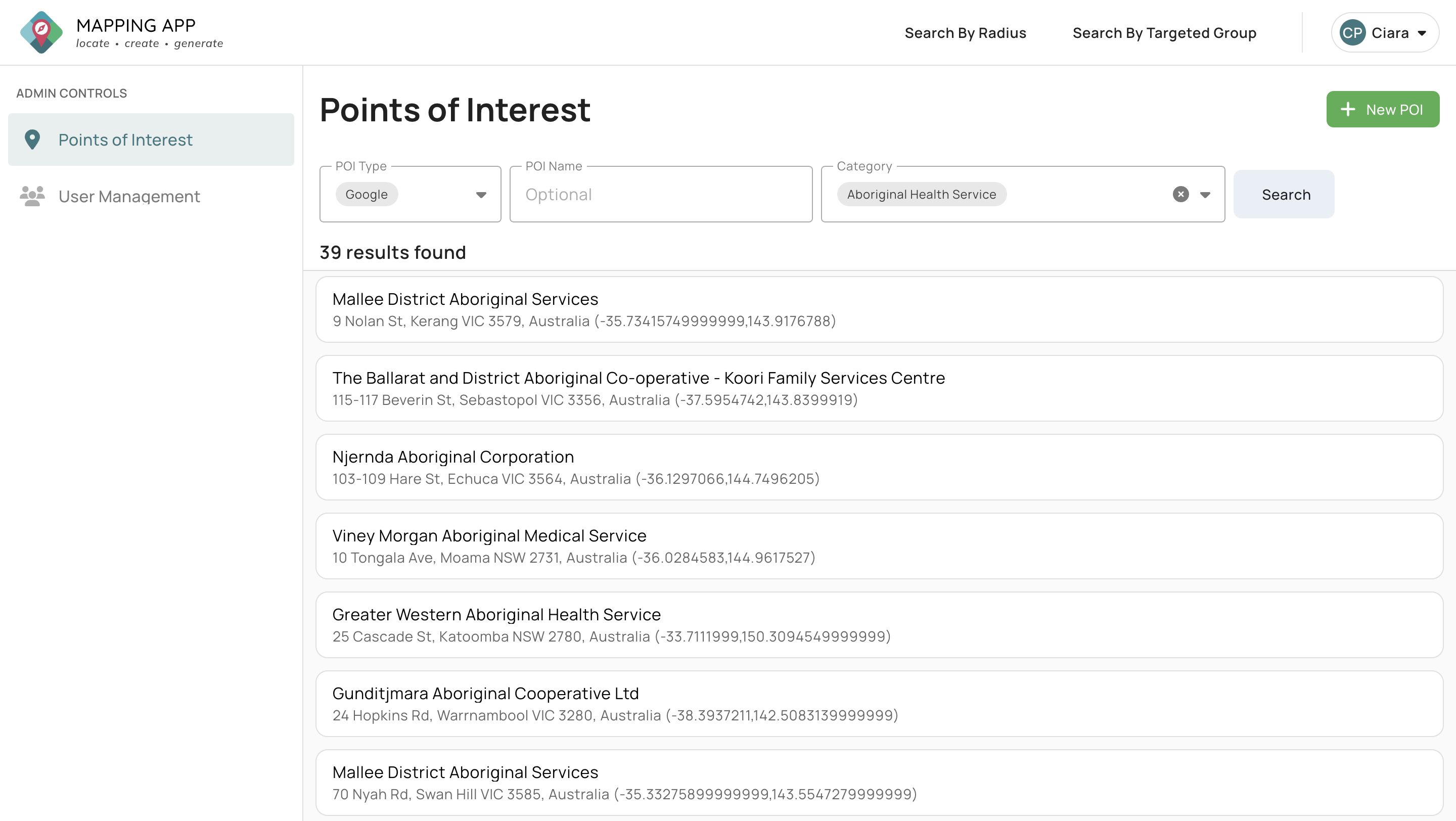
"Mapping App" is a web-based, information sharing map application created exclusively for staff from the community services sector in Victoria. The map predominantly features Google API-based points of interest that were chosen through co-design input from the sector, to ensure our design was inclusive of the needs of service providers. Users can then manually add their own listings, or customise existing listings with comments and tags.
The main points of interest featured on Mapping App are categorized as follows:
- Government services including Centrelink, police stations, and courts
- Public amenities such as places of worship, libraries and parks
- Vet clinics, pet boarding and pet stores
- Support services for vulnerable community members such as homelessness access points, community legal centres, and family violence services
- Medical services including GP clinics, hospitals, pharmacies and psychologists
- Public transport stops
- Private accommodation including hotels/motels, caravan parks, rooming houses, and Supported Residential Service facilities
- General amenities such as banks, supermarkets and laundromats
The "targeted client group" feature enables users to indicate which services have targeted programs that support specific client groups, such as victim-survivors or pregnant women, and allows staff to quickly find the services most suitable for their clients from priority cohorts via our custom filter.
Most importantly, Mapping App has a “community notes” feature, meaning staff from the sector can share knowledge with each other that will be stored in our database and updated in real time.
Project Innovation/Need
Staff from the community sector are experiencing high levels of burnout, and leaving roles at a rapid pace. Almost all support services have indicated a considerable increase in demand and client complexity. As Mapping App assists staff to access more knowledge, increase efficiency, and meet the unmet demand for their help, this will reduce staff stress levels and lead to better mental wellbeing outcomes.
Our product features all hotels and other emergency accommodation used by the community sector. An overwhelming amount of feedback collected by service providers indicates that their clients often feel isolated in hotels, disconnected from their support needs; Victim-survivors of family violence voiced that they returned to an abusive environment due to this factor. As Mapping App contains vital nearby amenity information, sector knowledge, and referral pathways for vulnerable clients staying in emergency accommodation, our product creates better outcomes for these clients by empowering the services supporting them.
Ultimately, Mapping App is a one-of-a-kind innovation, in the sense of how our technology connects to the development of the Victorian community services sector. There are no existing software products that assist our sector to share knowledge between agencies and amongst staff, whilst collecting wisdom for posterity from our experienced and diverse workforce before its loss during role changes – which happen frequently in a sector rife with burnout. Whilst some organisations have their own software, Mapping App is groundbreaking in its ability to educate and connect staff from the entire sector simultaneously and holistically.
Design Challenge
The NFP Tech director had spent five years collecting ideas informally via their roles in multiple areas of the Victorian community services sector, including family violence, youth work, and homelessness. While working on a former project and software product, the director liaised with 65 stakeholders across the sector and had the opportunity to meet numerous frontline staff and managers. When mentioning the issues and barriers that were preventing them from performing their work to the best of their ability, the idea for Mapping App surfaced, and was further refined by the NFP director in January this year under our newly formed charity.
In most circumstances, a project team would spend months liaising with stakeholders before beginning work on a software product, seeking formal input and fine-tuning wireframes until all details of the product are envisioned and solidified in totality. Instead, NFP Tech reached out to Doculocker to begin building the Mapping App without completing this process, with its design ideated by the knowledge of the director that was gained through their aforementioned sector experience.
Other design challenges included the following:
- As the Google information database is often inaccurate, the Doculocker team created a feature wherein data that appeared in multiple categories, or contained spelling errors, was flagged for inspection and correction
- Google Maps features points of interest from paid advertisers, which overshadow the results selected by users. Our frontend developer solved this issue by customising the map skin to remove all advertising, and altered the colour scheme to highlight the POIs appearing in the search
- As not all information can be found easily on Google, such as rooming house locations, the Doculocker team manually scraped alternative databases for POIs that were unavailable on the Google database
Future Impact
The project will lead to the following positive future impacts for the Victorian community services sector:
- Avoiding duplication of the community sector workforce’s efforts in searching for information, as one user can provide additions and/or updates on the app, which will instantly be shared with all others
- Enabling staff to access sector information on services in other areas that they are often unfamiliar with, particularly as regional/rural and metropolitan services that do not border each other often lack inter-organisational connection
- Saving staff time in manually creating databases with amenities to share with clients, as Mapping App uses Google API data when storing regularly cached details, meaning the information will automatically refresh itself as businesses update their listings on Google
- Allowing private sharing of sector expertise amongst the sector workforce, as we only enable access for staff and/or volunteers through an account linked to a community organisation
NFP Tech and Doculocker recently finalised a “beta” version of Mapping App, and a product trial has begun in the Yarra Ranges. Usage across Victoria will hopefully increase as the positive results illustrated during the pilot continue to grow, with an anticipated roll-out of Mapping App across the state set to commence in early 2026. Our ultimate goal is to empower the community sector workforce that is already buckling under time pressure to assist their clients, faster and more efficiently, with quick and easy access to the information they need, ensuring better futures for sector clientele.
NEXT Futures - Equity & Inclusion
Projects that expand and grow inclusion, integration, diversity and community.
More Details